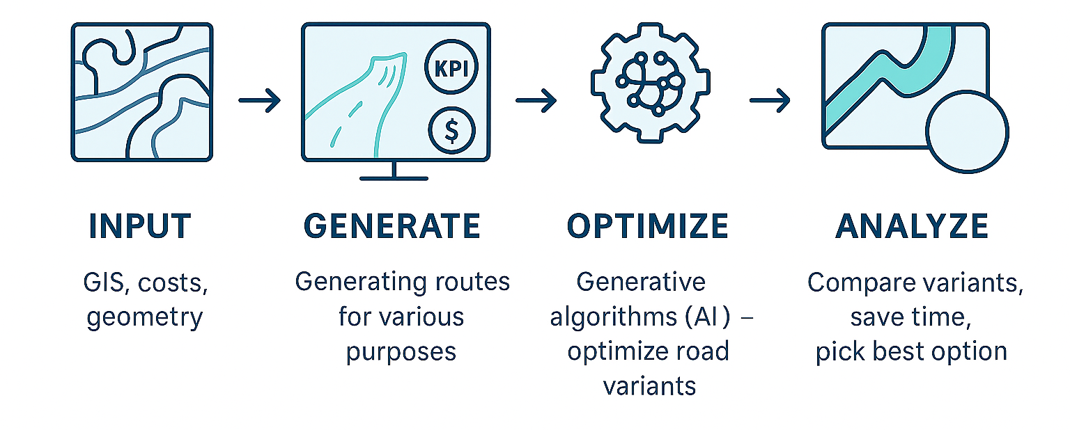
Imagine being able to redesign a road so that it costs less to build, fits the terrain better, and is more environmentally friendly. Sounds like science fiction? Not anymore! In my master’s thesis, I decided to test how modern tools – including the program Infraspace – handle the optimization of road alignments. The result? Up to 30% savings and some surprising conclusions that may interest every road engineer.
Table of Contents
Optimizing a road alignment is not just about lowering costs – it’s also about making the best use of available land and minimizing environmental impact. Using Infraspace and computer-based optimization algorithms, I compared different road variants, evaluating them in terms of construction costs, integration with existing infrastructure, and CO₂ emissions.
The outcome? Project costs were reduced by as much as 30%, proving that well-chosen digital tools can completely transform the way we design roads.
Case Study: Road Optimization
In my thesis, I focused on optimizing a road bypass alignment using modern digital tools. The goal was to generate and refine different bypass variants, starting with fixed start and end points. Using Infraspace, I produced six options, which I then analyzed and compared. These included sketches I made at the early stages, the existing bypass alignment, and the optimized bypass version.
The process involved 3D modeling, optimization algorithms, artificial intelligence, and environmental simulations. This allowed me to take into account not only technical requirements, but also terrain conditions, community needs, and ecological aspects. Road planning thus shifted from a time-consuming, intuition-driven process into a multi-stage, precise decision-making tool.
To achieve this, I used Infraspace, Trimble Quantm, and Rhino with the Grasshopper plugin, which enabled a comprehensive analysis and optimization of the bypass alignment – ultimately achieving savings of up to 30% compared to the designed variant.
Into Infraspace, I uploaded existing GIS data (.shp format), including:
- Buildings
- Protected natural areas
- Surface waters (lakes, rivers)
- Farmland
- Forest areas
Rhino and Grasshopper in Action
Before diving into optimization, I first had to “translate” the existing bypass alignment from traditional 2D documentation into a 3D model. Without a precise reference alignment, optimization would have been meaningless.
For this step, I used Rhino and its Grasshopper plugin. Instead of manually modeling everything, I chose to optimize the process itself. In collaboration with PORR, I developed a parametric script in Grasshopper. By loading just a few key 2D data points (such as the road axis and longitudinal profile), the program automatically reconstructed the alignment in 3D.
With initial or imported routes ready, I moved on to defining generation parameters – both geometric and optimization goals. From a single generation run, I could produce a dozen variants, select the most promising ones, and then move on to further optimization or analysis.
My work in Infraspace followed four repeating steps:
- Input data – GIS data, geometry conditions, preferences
- Route generation – optimization parameters
- Optimization – selecting the best variant or re-evaluating results
- Analysis – comparing outcomes
Road Optimization in Infraspace
Infraspace is a cloud-based tool designed for infrastructure projects – road, rail, powerline, and pipeline planning, design, and optimization. Its strength lies in combining AI-driven algorithms with engineers’ expertise.
The generative algorithm can handle multiple data sources, ensuring flexibility and precision. Supported inputs include:
- Digital terrain models (DTM)
- GIS data
- Custom project-specific data (costs, geometry, etc.)
It integrates seamlessly with existing workflows, supporting formats like:
- GIS vectors: ESRI Shapefiles, GML, SOSI
- Alignments: LandXML, DXF, TIT/NYL
- Terrain and subsurface models: DXF
- Export options: IFC, BCF, Excel, DXF, LandXML, ESRI Shapefiles
Infraspace also provides advanced visualizations of results, making them clear and easy to interpret for engineers, GIS experts, and project managers.
It fits perfectly into the global trend of digitalization and automation in infrastructure, enabling cost reduction, route optimization, and minimization of environmental impact. Large-scale adoption could significantly improve planning efficiency and project quality.
The Optimization Process – Step by Step
So what does a real-world route generation and optimization process look like in Infraspace?
Check out the video!
Summary
Modern technologies in road design and optimization – like Infraspace – are becoming a true “control center” for engineers. They allow us to quickly generate optimal alignments based on multiple criteria: cost, length, environmental impact – and integrate the results into common industry formats.
The secret lies in algorithms with strong mathematical foundations – from linear programming and genetic algorithms to AI-supported optimization. Instead of tediously comparing variants “by hand,” designers receive ready, precise, and context-specific solutions – often outperforming traditional methods in terms of time, cost, and quality.
