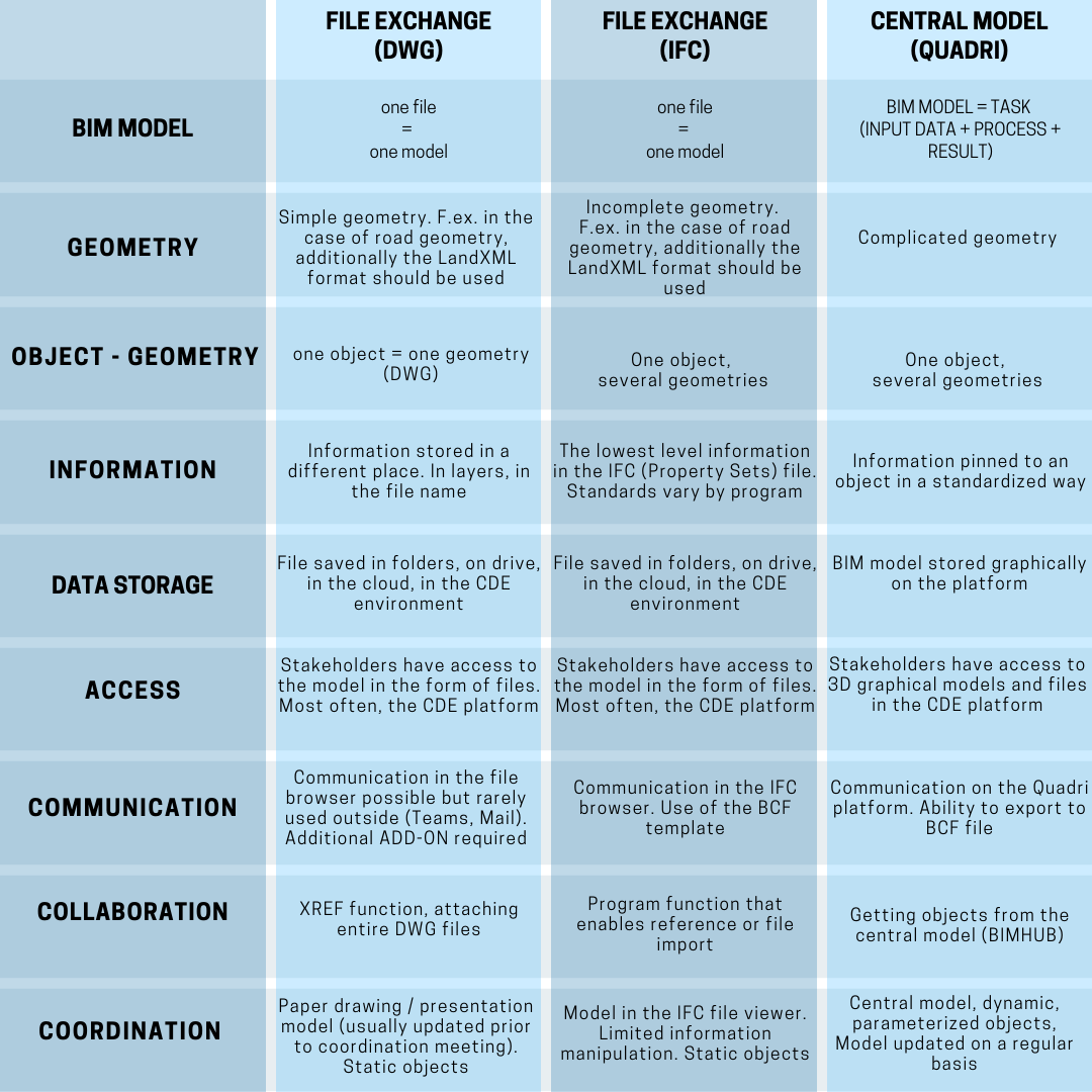
Access to data by all stakeholders in BIM projects. This is nothing new in file driven projects. However, the main assumption of cooperation based on a common, central BIM model is to provide all stakeholders with access to the platform on which the graphic models are located.
In order to better describe the issue of “working with the central model” I will explain the way the platform works Trimble Quadri. I chose this tool for two reasons. The first is the fact that it is the only solution on the market (I do not know others, if there is one, please let us know by e-mail) that allows you to work with BIM at level 3. Another fact is that I have been working with this platform since 2014. I wrote my master’s thesis on this topic. It’s fair to say that this is my favorite BIM tool that I know from A to Z.
Quadri is otherwise known as BIMHUB. A place where BIM models are stored graphically. To understand how the Trimble Quadri platform works, you need to learn the 3 most important elements of working in this environment. Tasks, objects and location.
In the second part of the article (2/2) I describe the way of working based on the central model. It is also an introduction to a series of articles about the Trimble Quadri platform.
Please read part 1, where I introduced the file-sharing method of working: CHECK HERE
Table of Contents
Working in Trimble Quadri - Tasks
Working in Quadri is based on tasks. TASK can be compared to an action expressed as follows:
TASK = INPUT + PROCESS + RESULT
The task saves the input / reference needed to execute the process and the result obtained. Input data can be other tasks / objects. The process can be the process of designing, modeling, setting, filtering data, conversion during import and export. The result is usually graphic objects.
Writing in a different way. A process is an act of manipulating input data that influences the result.
What is a process?
The process allows you to manipulate / parameterize such activities as object conversion, modeling, setting, filtering objects, adding information, displaying. Each process can be automated.
For example, tasks in Quadri can be described as follows:
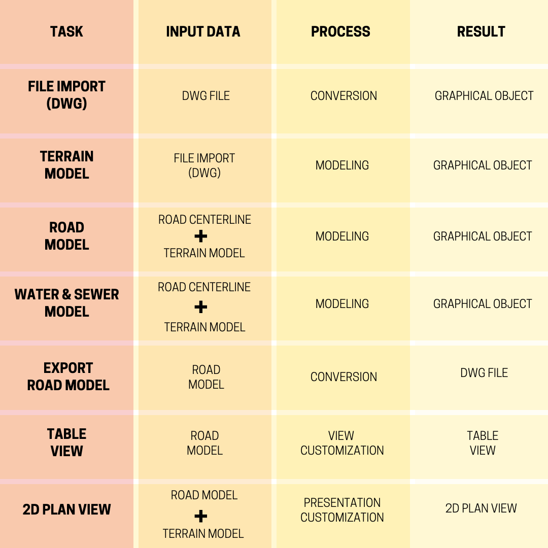
At this point, I would like to draw your attention to the tasks of the ROAD and the WATER & SEWER. Trimble Quadri is a BIM model management platform. This program has the ability to model the existing situation (this topic will be devoted to another article about Quadri). In addition, Quadri has, among others direct connection (Rest API) to the infrastructure design program as it is Trimble Novapoint. Hence, it is possible to create Novapoint tasks directly inside Quadri.
Work locally and on a server
In Quadri, we have the ability to work locally and on a server. When working in a local environment, we work in isolation, we do not share data with others, we can edit tasks at any time. Working on the server, we share data with other team members who are invited to the Quadri environment. At this time, to edit a TASK, it must first be “reserved”. We can then edit the task. The changes will be visible to others the moment we “release” the TASK. A big advantage is also the fact that the TASK change history is saved on an ongoing basis.
Task dependency
Because TASKS are used as a reference in other tasks. We can track the dependencies between different objects and indicate which of them were used to present the following result.
Below in the graph we can see what this dependency structure looks like. For example, to create the “Main road” TASK, the “Calculation basis” TASK and the “Main road CL” TASK were used.
The graph also shows other dependencies between tasks that affect the end result. For example, we can define which tasks use the task (Main road) as input (BRIDGE, Tunnel modell, etc.) and which tasks, for example, form the task (Main Terrain).
When we update, edit or replace a task, the change will be visible in all other elements where there is a dependency with this task.
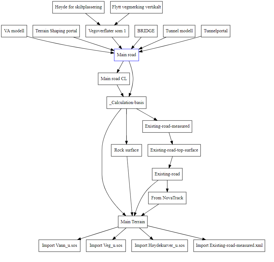
Simply put, the task “Main Road” can be called a BIM model, which is graphically represented by a result that is made up of Quadri objects.
BIM objects in Quadri
Quadri can display most geometric shapes. Lines, arcs, points, curves, clothoids, mesh surfaces, tin, solids, etc. At this point I mention that Quadri has a direct connection (API connector) to Grasshopper, which is known to be able to create complex geometry.
Each object in Quadri is part of a collection of objects called an feature catalogue. It is object library based on ISO 19100. The Quadri catalog is available here. This catalog includes physical objects and phenomena (such as traffic accident, speed limit). Examples of objects are: traffic lights, safety barriers, alignment, terrain, bus stop, cant etc. Object catalogs may vary depending on the context of the model and the type of project.
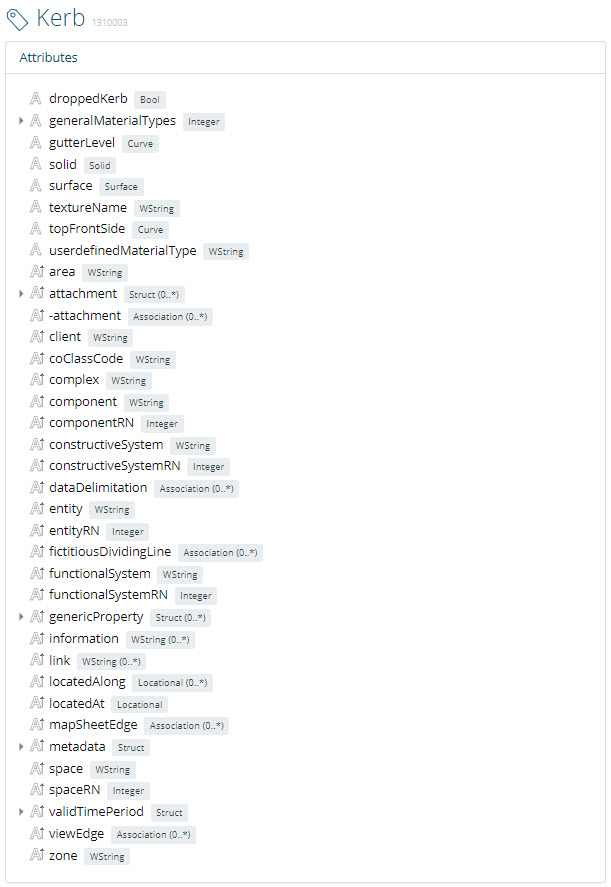
An object can have several geometries simultaneously. For example, an object: “Kerb” can be represented by surfaces, solids, and lines.
Each object in Quadri, apart from geometry, has attributes to which information can be assigned (number, date, text). The list of attributes and predefined values can be defined in advance. What does it mean? Before starting a BIM project, the BIM Coordinator determines what properties should be used in the project, then configures the set of attributes and adds them to the object directory. This method allows you to quickly add information to each object in the model later.
So the advantage of work based on the central model in Quadri is that we can import objects to it from different files, or send them using connectors (more on this below) and bring them to one common standard. All objects with a standardized name with the information in the right place.
One object, one geometry
In the CAD environment. One geometry is assigned to one feature. There are such objects in CAD as CadSurface, CadLine, CadPoint. Objects can be distinguished from each other by layers.
Location in Quadri
The Quadri uses the Coordinate Reference System (CRS) and the Linear Reference System (LRS).
The first one helps to determine in which zone the project is carried out. The linear system helps to locate objects along the reference transport system.
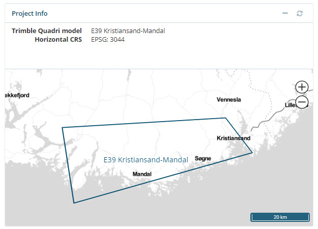
For example, the lighting mast is located at point x, y, z in the NTM XX zone. In addition, its location may be determined, for example, along a specific road, at kilometer XX etc.
Reference system
The DWG file does not carry information about the reference system in which it was designed. This can lead to costly design errors.
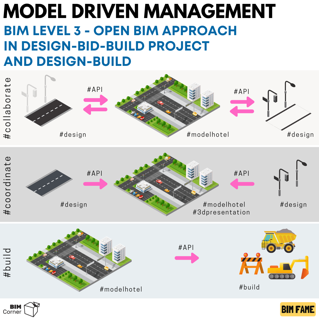
Collaboration across domains
In a collaborative approach based on a central model, all stakeholders have access to one common BIM model (federated model) presented in a graphical form. Each of the stakeholders can view the model via a desktop and web application. The model is constantly updated. This solution increases the frequency of using the multidisciplinary model as a preview during design works.
For file driven management, the federated model is very rarely used in other places than during coordination meetings due to its very rare update.
Trimble Quadri allows you to extract objects, convert them and generate files from them that can be read into various systems based on file-based collaboration. It is worth mentioning here that Quadri has an API connection (direct) with CDE environments such as: Trimble Connect, Project Wise.
However, the greatest strength of Trimble Quadri is its direct connection to the most popular authoring software on the market. Via API we can send and download objects from programs such as:
- Revit (e.g. buildings, bridges, tunnels)
- Civil 3D (e.g. terrain, road, sewage system)
- Open Road (e.g. road)
- Tekla (e.g. Bridge, tunnels)
- Sketchup ( eg. area, small architecture)
- Novapoint (eg. Railways, roads, sewage systems, tunnels, bridges, signs)
- Trimble Business Center
- Tilos (scheduling)
- Quantm (early conceptual planning)
Thus, in contrast with the approach of cooperation based on the files in the case of this approach, we will select only those objects that interest us. We do not need to attach heavy DWG and IFC files in order to obtain a design reference. An edge line or a point may be sufficient. We send data, not files!
The two-way connection ensures lossless and dynamic transmission of the geometry. We don’t have to give up our favorite design program. We don’t need to export our model to an IFC file.
Compared to the approach based on file exchange, we gain time on each conversion and export of files to different formats, and then importing to another application. In this case, we do the conversion only once, on the Quadri side.
Way of working in Quadri
In order to send objects from the central model to an external application, create a TASK for a connector on the Quadri side (the list of programs above). Then, indicate the input data (eg terrain + bridge abutment). In this way, the designer is able to download only the objects of interest directly from the central model to his design program.
In the design program, using ADD-ON (previously installed), select the task created in Quadri and then download the selected data, which will serve as a reference. Then, in this program, we perform the necessary operations, create an discipline model.
We do the same when sending the model back to Quadri. In the authoring program, select TASK (created in Quadri) and click the send button to send the selected objects back to the central model. Information is converted and mapped between the data transmission. Once set, the conversion can be used again.
The advantages:
– shorten and simplify the process of data transmission (only one conversion),
– we do not lose data as in the case of exports and imports to file
– as a reference, we use only the selected objects, and not the whole model
Coordination
Cross-domain coordination based on the central model works very well in the case of Design-Build projects, where the Contractor-Designer-Investor usually cooperates actively throughout the entire contract. In this approach, the design model is up-to-date (updated daily, even more often) and presents the current state of the project depending on the phase in which the project is at. The software enables real-time collaboration.
Designers may be concerned about this form of collaboration. Design companies do not want to share their design model as they are afraid to reveal their know-how. Many companies also fear that their design processes are chaotic. Sharing the model could indicate a lack of professionalism and a low level of efficiency. It’s always easier to send a “structured” DWG / IFC file
In my opinion, it is worth sharing the data designed in the form of a central model as early as possible. This solution helps establish a good dialogue with the parties involved. This also affects the quality of the models. The models are more optimal and buildable (adapted to the conditions on the construction site).
Updating the federated model (FILES vs CENTRAL MODEL)
I would compare up to date model of federated model to the current weather forecast.
In the case of file driven cooperation, the multi-discipline model is closer to the current forecast in the local newspaper (forecast for a week, forecast for two weeks).
In the case of cooperation based on the central model, you can easily compare it to the weather forecast provided in the mobile application, which is refreshed every now and then (every 1 minute, every 1 hour).
What source, such a forecast.
The executive phase and the central model
Thanks to the fact that the contractors have direct access to the central model, they can, among others, view the progress of design work, update calculation data (construction data), comment on technical solutions, or even add comments inside the model.
Collaboration based on a central model favors the models being “buildable” and adapted to real conditions. This way of working reduces the risk of rework / additional work.
The early involvement of the contractor in the planning and design process allows, in most cases, to save time and money for the companies involved in the design.
In addition, having access to Quadri, the contractor at the implementation stage can f.ex. export the data that interests him to formats that are supported, for example, by machine control systems on the construction site.
Summary + infographic
Work based on the central model is a completely different approach compared to work based on file exchange. Faster communication, data flow, not files, access to current data.
Analyzing the description of what BIM is at level 3, we will find there, among others assumptions such as: all BIM platforms connected, free flow of data, centralization of project documentation attached to the BIM model, all stakeholders have access to data, the model is updated on a regular basis.
All of this fits well with the Quadri description. This is undoubtedly a game changer on the infrastructure market. This platform allows you to adapt to any project regardless of the level of advancement.
Let me know if you want to know more about this platform, which is the market leader in Norway (the most advanced BIM market in the world). If you have any questions, please send an email to: [email protected]