

When industry professionals talk about digital transformation in construction, they usually imagine BIM coordinators sitting in air-conditioned site offices, clicking through 3D models or running clash checks. In my experience, they rarely picture the surveyor out in the rain with a total station and a field controller.
However, what I have observed, is that the model-based project delivery has transformed the surveyor’s job more than almost any other role on site. On complex Design and Build infrastructure contracts, 3D models and digital tools have unfortunately not reduced the surveyor’s daily workload, but instead of that, they have expanded it.
The background
On traditional 2D projects, a surveyor’s scope had clear boundaries. They received approved paper drawings, established control points, staked out lines on site, and checked finished elevations. On model-based jobs, that boundary has disappeared. Surveyors manage a constant flow of spatial data moving between design offices, field rovers, and heavy machinery. Beyond setting out and measuring, their daily routine now includes machine file prep, geometric checks, and spatial coordination across the entire job.
In my article about BIM&GIS integration, I have mentioned in point 7 that as BIM and GIS merge, the surveyor’s job is changing completely.
In this article, we will have a look at what the surveyor’s job actually looks like on a modern model-based project, why their responsibilities have grown so much, and how project teams can support them.
As always, a short disclaimer: I am writing about my own observations, on a specific project, with specific requirements. Please remember that each project is specific and has its own challenges.
Table of Contents
1. Navigating The Constant Flow Of Design And Build Data
2. Connecting Field Measurements Directly to Project Data Repositories
3. Working Hand in Hand with Design Teams
4. Preparing Data for Earthmoving Machine Control
5. Checking Real-World Execution Against Digital Design
6. Handing Over 3D As-Built Models and Asset Data
7. All This In Addition To Traditional Geodetic Work
1. Navigating The Constant Flow Of Design And Build Data
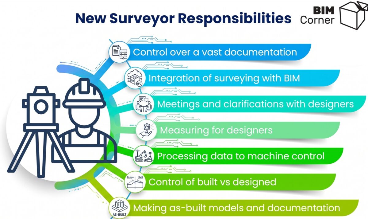
On traditional contracts, design revisions used to arrive slowly and formally. On a Design and Build project, with high BIM requirements, design work happens in some cases alongside active construction. Surfaces, alignments, and structural profiles can be updated and evolve quite often, in some cases even every week.
Because the surveyor is responsible for setting out what actually gets built in the ground, they have to track every design update. Before heading into the field, a surveyor must verify several critical details, like for example:
- Which model revision is currently approved for construction in a specific section?
- Has the design changed since the previous files were sent to the site?
- Do the 2D excavation drawings on the project platform match the 3D surface model provided by the road designer?
When a designer updates an alignment or shifts a drainage pipe, that change has to reach the site before crews start digging. Because revision notes rarely highlight every minor geometric tweak, surveyors spend significant time running version comparisons -overlaying new surfaces and linework on top of old ones – to spot unannounced shifts. Sorting through revisions, extracting clean setting-out lines, and managing spatial files across civil, structural, and utility trades requires heavy office preparation before any field work begins.
2. Connecting Field Measurements Directly to Project Data Repositories
Surveyors no longer work in an isolated CAD environment. On modern jobs, they interact directly with the Common Data Environment and digital repositories.
Connecting field surveying to digital project workflows requires deep technical knowledge. Surveyors must handle a wide range of data formats every day:
- Converting between native CAD formats, LandXML files, open IFC models, GIS layers, and raw point clouds (+ others).
- Managing coordinate reference systems, transforming local project grids to national geodetic systems, and applying scale factors correctly in modeling tools.
- Controlling naming conventions.
- Checking file suitability codes and approval status metadata before pushing points to field data collectors.
For example, when a bridge designer uploads an updated file, the surveyor doesn’t just open a drawing. They audit the revision against previous versions, extract setting-out linework and point files for field controllers, and verify that the new pier elevations match the physical foundations already built on site. If the updated digital deck shifted 15 millimeters off the real-world pile cap, they catch that discrepancy before steel gets fabricated.
3. Working Hand in Hand with Design Teams
Model-based workflows create a constant loop between the site and the engineering office. Designers in the office need real-world data to verify their assumptions, and surveyors are their main source of field truth.
Designers frequently request targeted site measurements during both design and construction phases. Surveyors get called out to measure exact clearances under existing bridges, map underground utility depths, or scan some specific objects. That real-world geometry goes straight back into designers’ authoring tools.
When physical site conditions do not match the digital model, the surveyor is usually the first person to spot the problem. If a rock layer appears higher than predicted in the geotechnical model, or an existing gas pipe clashes with a new retaining wall footing, the surveyor brings field evidence to the table. They join technical meetings with design leads, presenting point clouds and cross-sections to explain site constraints. Rather than just reporting errors, they help designers adjust model geometry to fit real ground conditions.
4. Preparing Data for Earthmoving Machine Control
One of the biggest operational shifts on civil sites is the widespread use of 3D Machine Control. Heavy equipment like excavators, dozers, and motor graders now rely on GNSS receivers (high-precision satellite positioning systems, including GPS), optical total stations, and onboard computers that guide hydraulic blades and buckets automatically.
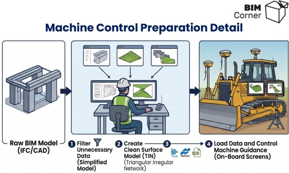
However, machine guidance systems cannot read a raw IFC building model or an unstructured CAD file. Heavy machinery requires specialized surface models and linework.
The surveyor is responsible for preparing and managing all machine control data:
- Stripping away unnecessary model elements and building clean surface models.
- Creating 3D linework, breaklines, and alignment files for trenching, road layers, and subgrade shaping.
- Pushing updated files to equipment controllers through cloud telematics or USB drives across long project corridors.
If a dozer operator grading a road bed works off an outdated file, the contractor faces expensive re-work and lost time. The surveyor carries the weight of making sure every machine on site runs on the correct, current model version.
5. Checking Real-World Execution Against Digital Design
In traditional construction, quality checks often happened days or weeks after a structure was built. By then, fixing an error was difficult and costly. In model-based construction, quality control happens almost immediately.
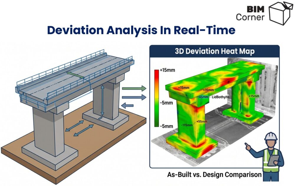
Using laser scanners, drones, and GNSS rovers (portable survey poles powered by high-precision satellite positioning), surveyors perform regular comparisons between built geometry and design models:
- Creating color-coded deviation maps by overlaying scanned point clouds of poured concrete or earthwork layers onto the 3D model.
- Verifying that constructed tunnel linings, bridge piers, and retaining walls meet contractual tolerances.
- Detecting execution drift early, before it causes clashes with following trades or precast structural elements.
Instead of filling out static paper forms long after the work is done, surveyors provide visual 3D deviation reports. This allows site managers to make immediate corrections while crews and equipment are still in place.
6. Handing Over 3D As-Built Models and Asset Data
A surveyor’s job does not end when concrete is poured and earthworks are finished. Handover requirements on modern model-based projects demand detailed digital documentation alongside final physical structures.
Clients no longer accept basic paper redline drawings. Surveyors must deliver structured digital asset data, like for example:
- Updating original design models or creating new 3D geometry to reflect exact field locations of buried pipes, track alignments, and structural elements.
- Attaching asset metadata, classification codes, installation dates, and material records required for asset management systems.
- Capturing photo records and laser scans of underground utilities before trenches are backfilled.
In the big picture, the surveyor actively shapes the final digital twin that the client will use to operate and maintain the infrastructure for decades.
7. All This In Addition To Traditional Geodetic Work
The hardest part of this shift is that new digital duties have not replaced core surveying work, but they have been added on top of it.
On any major infrastructure project, surveyors still carry out essential field duties:
- Establishing and maintaining primary geodetic control networks. If a primary reference point shifts by even a few millimeters, every model overlay, machine guidance target, and setting-out point across the project shifts with it.
- High-precision structural stakeouts. Setting out bridge bearings, track slabs, and anchor bolts using optical total stations where tolerances are measured in single millimeters.
- Physical monitoring and levelling. Running precise levelling loops and monitoring settlement or structural movement over time.
Surveyors still manage and are responsible for measurement while simultaneously serving as digital spatial data managers.
8. How Project Managers and BIM Leads Can Support Surveyors
If contractors want model-based projects to run smoothly without burning out their survey teams and reduce risk for mistakes or delays, management needs to adjust its approach:
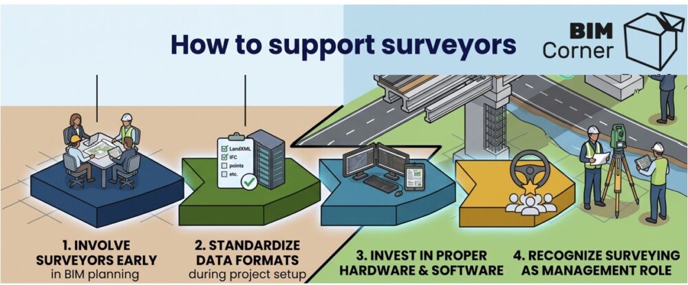
- Involve surveyors early in BIM planning. Do not write the BIM Execution Plan in isolation. Bring the lead surveyor into the room when establishing coordinate systems, grid-to-ground scale factors, and data delivery points.
- Standardize data formats during project setup. Agree on exact file formats for machine control, GIS layers, and point clouds during early mobilization. Do not leave file conversions as a last-minute surprise for field staff.
- Invest in proper hardware and software. Processing dense point clouds and building machine control surfaces on a standard office laptop creates severe bottlenecks. Provide high-performance workstations and specialized terrain processing software.
Recognize surveying as a core management role. Stop treating surveying as a commodity trade service. The lead surveyor belongs in regular coordination meetings alongside design leads, project managers, and BIM leads.
Summary
Moving to model-based project delivery has elevated the site surveyor’s role. Their work reaches far beyond pounding wooden stakes in the dirt. They provide the practical link connecting digital designs to physical construction.
By managing vast flows of project data, feeding automated machine fleets, conducting 3D deviation checks, and building final digital asset records, surveyors carry a major portion of project risk. Recognizing their expanded workload and giving them the right tools and seat at the planning table is one of the smartest moves a project team can make to improve the communication and work efficiency on model-based projects.
👉 How about you? Do you have experience with BIM and surveying, or GIS, on model-based projects? Share your experiences in the comments – let’s learn from each other and move the industry forward.